The current temperature is 39° under skies delivering light-rain and windy conditions. We are warmer right now than we will be by later today, when the high is forecast to drop down to 36°. The sun will rise today @ 8:15 a.m. and set later @ 5:30 p.m.
Yes, the days are getting longer, but they are also mostly gray too. However, there is NFL playoff football on TV this afternoon and evening. I'm still awaiting an annual rite of spring, the opening of MLB™ Spring Training 2020, a mere 33 days from now, when the pitchers and catchers report for my beloved Red Sox.
There is a Winter Storm Warning in effect until 7:00 a.m. tomorrow, January 12, 2020 for most of the Lakeshore Communities in West Michigan. The NWS is forecasting heavy mixed precipitation with a total snow and sleet accumulations of 2 to 4 inches All of the initial information seems to say that it won't happen here in "The City", but I call B.S. on that one, as the forecast is for all of Ottawa, County MI. What are the odds that it won't land on GH?
There are likely to be ice accumulations of one tenth to one half of an inch with the highest amounts expected east of Grand Rapids. That part of the forecast I want them to be right about, with winds gusting as high as 35 mph. in portions of central, south central and southwest Michigan. Some people can expect power outages and tree damage due to the ice. Travel may become impossible, and clearing efforts will be very difficult due to the amount of sleet expected. It is strongly suggested that drivers keep an extra flashlight, food, and water in their vehicle in case of an emergency.
There is also another Gale Warning in effect from St Joseph to Manistee from 7 a.m. today until 1:00 a.m. tomorrow. Strong winds will cause hazardous waves which could capsize or damage vessels and reduce visibility. Mariners should alter plans to avoid these hazardous conditions, remain in port, seek safe harbor, alter course, and/or secure their vessel for severe conditions. Ya think?
Northeast winds of 15 to 25 knots will be increasing to 35 knot gales and waves of 3 to 10 feet are expected. Surfs up? It is a good thing that we got out yesterday, although there a few errands that didn't get run as planned.
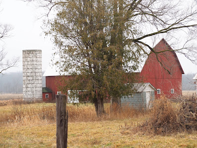
We traveled to Muskegon and parts of northern Ottawa County before heading home by way of Stan's. Along the way, I once again had my trusty Olympus DSLR camera at the ready and with some good fortune on the back roads, I was able to get many pix of my new favorite, Michigan farms and their accompanying equipment and out-buildings. I'll add some of the more interesting ones now.
 |
| This one had the words Willow Ranch in faded lettering on its roof, but I couldn't find any additional information about that particular building. |
 |
| Like an idle playgrounds, dormant farm equipment is just waiting to be put to use. |
 |
| This is a view of another of the farms that has been converted into an event venue near Coopersville, MI. |
 |
| A seemingly newer structure is on a working farm near Ravenna, MI, a small community in northern Muskegon, County. |
 |
| Much the same. |
 |
| We decided to head home with the fog starting to settle in as we drove. |
I am nearly done with my current read entitled 1st to Die, by James Patterson. This book was written by Patterson before he began to use another writer in the writing process. Mary likes that I have branched out to thrillers/mysteries that have women as their primary characters. She is already amazed that I like Amish mysteries and romances. She caused that as she introduced me to that genre when we were vacationing in Florida.
Today, the fur-children will not be getting a walk due to the weather. We'll be in the kitchen and doing still more indoor chores. How we manage to create a need for so much laundry with just the two of us is a mystery. I like to stay ahead of the laundry, one of my little idiosyncrasies. I chalk it up to one of the many things that are purportedly part and parcel to my being born a Virgo.
Otherwise, all is well. Ciao.

No comments:
Post a Comment
Note: Only a member of this blog may post a comment.